While it is common knowledge that Michael Phillips was the first white man to explore the Crowsnest Pass in 1873, many people are unaware of an earlier explorer who should have found the Pass route but didn't. He just plain missed it. Kinda like that turnoff on the freeway you never see till you've long since passed it. He just sort of blew by it.
The explorers name was Thomas Blakiston, a remarkable man who like a lot of wealthy Englishmen back in the glorious days of the British Empire chose to wander the world from one challenge to another. Blakiston joined the "Palliser "expedition in 1856 at the age of 25 and was appointed magnetic observer a year later.
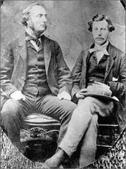
Expeditionists Captain John
Palliser and James Hector,
The Palliser expedition was set up to determine the value of the vast prairie region of Western Canada and along with geographer Captain John Palliser and Blakiston; it had two other renowned explorers. They were James Hector –geologist, naturalist and surgeon and Eugene Borgeau –botanist. The explorers amassed astronomical, meteorological, geological and magnetic data, and described the country, its fauna and flora, its inhabitants and its "capabilities" for settlement and transportation.
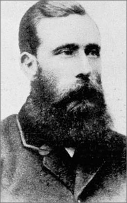
Thomas
Wright Blakiston 1832-1891
In 1858 Thomas Blakiston wound up heading his own expedition to explore the southern Canadian Rockies to determine the possibility of potential routes for a railroad. He started out west of Calgary and travelled south along the eastern foothills down a route close to what we now call the Longview Road or Highway 22. At one point as he crossed the Oldman River at Maycroft he notice a prominent "dome shaped" mountain to the west through a gap in the Rockies and named it "Gould's Dome" after the renown British ornithologist, "John Gould". He also noted that the "gap" he viewed it through was the only break in this eastern range for 25 miles and that no one point on that range had any prominence. He named the range after the famous missionary and African explorer Dr. David Livingstone, the man of whom H.M. Stanley of the New York Herald asked the famous question - "Doctor Livingstone, I presume?
Blakiston then carried on south, crossing the Crowsnest River and then headed south and west up the Castle and Carbondale Rivers, crossing over the North Kootenay Pass and down into the Flathead Valley. He then followed the Flathead River west to the top of Flathead Ridge where upon he claimed to have observed, way to his north that dome shaped mountain he had named earlier. Others claim what he probably saw was Crowsnest Mountain while it is entirely possible he saw the "domed" section of Trinity Mountain in Fernie (often misnamed the Three Sisters)
His expedition then proceeded down Lodgepole Creek to the Wigwam River where he observed 200 to 300 foot high cliffs that he named the North Bluff (Mt. Broadwood).
Blakiston then headed south down the Rocky Mountain Trench, crossed the yet to be surveyed International Boundary (49th Parallel) and wound up at "Fort Kootanie" on the "Kootanie River" where he made contact with the local Indians. He then turned eastward and travelled up Grave Creek, Trail Creek and once again across the Flathead River 25 miles south of his previous westward crossing.
From there it was eastward up the Kishinina River and through the South Kootenay Pass into what was once called Kootenay Lakes and is now known as Waterton Lakes. He named Waterton after the celebrated British naturalist Charles Waterton. Once out on the eastern foothills again he determined to head back to Fort Edmonton where the Palliser expedition was to spend the winter. His final camp was on September 12, 1858 at the forks of the Belly (Oldman) River, having taken just over 30 days to conduct his survey.
Ironically, directly west of his final camp lay the "Crows Nest Pass", a route he had completely missed. A note from his journal says it all. "The Crows-nest Pass, of which I have marked the general direction on the plan, follows up Crows-nest River; a tributary of the Belly River , into the mountains and gains the west side near the "Steeples". By report of the natives it is a very bad road and seldom used"
To the First Nations peoples in the area a bad road had more to do with obstructions than degrees of railroad grade and so it would be another 15 years before the Pass was discovered. Even more ironically, 154 years later the word out there now is that the Pass route is still a "bad road", now full of cattle liners and red neck drivers with quad trailers.
Blakiston’s later adventures are a story unto themselves. In 1861 this intrepid explorer led an expedition up the Yangtze River in China, travelling 1500 kilometres further up the river than any Westerner had previously reached. After retiring from the army he visited Japan by way of Russia and Siberia where he pursued business interests. During the 1870's, he compiled a catalogue on the birds of Japan which was the authoritative document for years in that country.
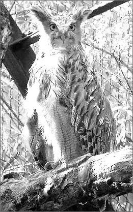
Japanese
fishing owl named after Thomas Blakiston
From 1861 to 1884 he was considered the foremost expert on birds of Japan and there is a fishing owl from Hokkaido that is named after him. Blakiston's fish owl is revered by the Ainu peoples of Hokkaido, Japan as a Kamuy (divine being) called Kotan koru Kamuy (God that Protects the Village).
Thomas Blakiston died in 1891 in San Diego, California never knowing that that “bad road” he missed was to become the southern route for CPR through the Crowsnest Pass.
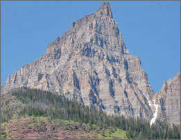
Spectacular Mount Blakiston-Waterton
National Park.